| FAQ |
| Members List |
| Calendar |
| Search |
| Today's Posts |
![]() |
|
| Chat and Games Looking for forum games, and completely off topic banter - this is your place! (includes Virtual Big Brother type forum games) |
| Register to reply Log in to reply |
|
|
Thread Tools | Display Modes |
|
|
|
|
#2 | |||
|
||||
|
Crimson Dynamo | The voice of reason
|
|
|||
|
|
|
|
#4 | |||
|
||||
|
Crimson Dynamo | The voice of reason
|
Its pretty much the same but adds a chance of a sat shower around 7 or so and sunday adds some afternoon showers
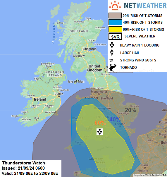
Below is the Munster regional forecast from your Met Office TOMORROW - Saturday 21st September A good deal of cloud about on Saturday morning with patches of mist, fog and any drizzle clearing. Dry for the rest of the day in most parts with sunny spells. However, some heavy showers will develop in south and east Munster during the late afternoon and evening. Top temperatures of 17 to 20 Celsius in light to moderate northeast winds. National Outlook Saturday night: Continuing cloudy with further scattered showers extending to most areas on Saturday night. It will stay dry in the west and north with clear spells. Lowest temperatures of 8 to 13 degrees in a light to moderate north to northeast wind. Sunday: Showers in Leinster and Connacht will become more isolated Sunday morning. Cloudy across the southern half of the country, with rain moving in from the east later, turning heavy and possibly thundery at times. Staying dry with sunny spells further to the north. Highest temperatures of 15 to 19 degrees with a light to moderate north to northeast wind. Sunday night: Rain will continue in the south on Sunday night, slowly edging southwards, but it will be dry across the rest of the country. Lowest temperatures of 7 to 12 degrees in a light northerly wind. Some patches of mist and fog developing. |
|||
|
|
|
|
#7 | |||
|
||||
|
Crimson Dynamo | The voice of reason
|
West Midlands region Forecast for Saturday
After a cloudy start, scattered showers soon develop across the region, heavy at times and bringing a more widespread risk of hail and thunderstorms. Feeling breezy in the showers. Maximum temperature 21 °C. |
|||
|
|
|
|
#8 | |||
|
||||
|
Crimson Dynamo | The voice of reason
|
Storm now on Reading and Swindon
|
|||
|
|
|
|
#10 | |||
|
||||
|
Crimson Dynamo | The voice of reason
|
|
|||
|
|
|
|
#12 | |||
|
||||
|
Crimson Dynamo | The voice of reason
|
|
|||
|
|
|
|
#13 | |||
|
||||
|
Crimson Dynamo | The voice of reason
|
|
|||
|
|
|
|
#14 | |||
|
||||
|
Crimson Dynamo | The voice of reason
|
Monday:
Amber warning or rain Midlands Hull across to Gloucester Stoke across to Peterborough An area of heavy rain is expected to develop across central and southern England during the early of hours of Monday, edging north and west and then becoming slow-moving somewhere across the warning area for several hours. It will then weaken and move away eastwards later Monday evening and overnight. Not all counties within the warning area will be equally affected, but it seems likely that some areas will see 60-80 mm and a few places may receive 100- 120mm or more. This is likely to result in travel disruption and some flooding. https://www.metoffice.gov.uk/weather...a-21352bfff55e |
|||
|
|
|
|
#15 | |||
|
||||
|
Crimson Dynamo | The voice of reason
|
Oxford has seen its highest rainfall total in 56 years in the last 24 hours.
the University of Oxford’s Radcliffe Meteorological Station, which recorded 77.1mm of rainfall in the last 24 hours, from 9am yesterday (September 22) until 9am today (September 23). According to the station, this is the fourth highest daily precipitation total ever in Oxford and the highest in 56 years, since July 10 1968. |
|||
|
|
|
|
#16 | |||
|
||||
|
self-oscillating
|
Thunderstorms have hit southern parts of the UK with one confirmed tornado in Aldershot.
More storms and heavy rain are expected over the weekend with yellow Met Office warnings in force. On Saturday there is the risk of lightning, intense rainfall, hail and gusty winds across Wales, central and southern England. By Sunday, further heavy rain will spread with continued risk of localised flooding and travel disruption. ---------------------- Nobody would notice in Aldershot
|
|||
|
|
|
|
#17 | |||
|
||||
|
Crimson Dynamo | The voice of reason
|
Quote:
|
|||
|
|
|
|
#18 | |||
|
||||
|
self-oscillating
|
wow thats pretty fierce
|
|||
|
|
|
|
#20 | |||
|
||||
|
Kate! | IntoxiKated
|
It's really warm here, in Bridgnorth atm, train heading back into Kidderminster shortly.
__________________
![]() Spoiler: |
|||
|
|
|
|
#22 | |||
|
||||
|
Senior Member
|
|
|||
|
|
|
|
#23 | |||
|
||||
|
Crimson Dynamo | The voice of reason
|
|
|||
|
|
|
|
#24 | |||
|
||||
|
Benjamin | I Love Niamh’s Brick
|
Flooding has caused some rail delays around Bristol/Cardiff/Gloucester trains
__________________
It's never too late to be who you once could have been... Spoiler: |
|||
|
|
|
|
#25 | |||
|
||||
|
Crimson Dynamo | The voice of reason
|
Hurricane Helene is to arrive Florida Gulf Coast on Thursday
|
|||
|
|
| Register to reply Log in to reply |
|
|